
US admits 'unfortunate error' after mislabelling countries on map of Africa
What the report says
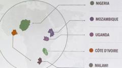
The US State Department has apologized after a presentation at an HIV/AIDS conference in Rio de Janeiro showed a map of Africa with major mistakes, including Nigeria appearing landlocked and Ivory Coast placed in East Africa. BBC Africa reported that the slide was used during a talk on Washington’s funding for HIV programmes at the International Aids Conference in Brazil, and that the image also distorted several country shapes. The errors were first highlighted online after HIV expert Emily Bass shared a photo of the slide.
According to the State Department, the problem was an “unfortunate error” and the agency said it took full responsibility for the confusion caused for attendees and African partners. A spokesperson said the slide deck had been hurriedly changed shortly before the event. Reuters later reported that the image included an AI watermark, suggesting it had been made with artificial intelligence tools, and OpenAI said it was looking into the report.
The episode drew criticism from US politicians and former officials, who described it as embarrassing and a sign of weak supervision. It also landed at a sensitive time for US global health policy, as the Trump administration has cut foreign aid and is reshaping HIV assistance. BBC Africa said Pepfar’s core treatment work has mostly continued, but other areas such as prevention and surveillance are being reduced.
Loading debate for this article…
Other publishers covering this story
Related reporting
 Manchester derby VAR officials stood down from weekend Premier League gamesAl Jazeera
 What could stop the Houthis’ advance across Yemen?Al Jazeera
 Inside the Houthis’ expanding war economy in YemenAl Jazeera
 Austria denies entry to Iranian official after UN rulingAl Jazeera
 Macklemore dropped from Ed Sheeran tour following Palestine advocacyAl Jazeera
 What Do the Houthis Want?New York Times World