
The map was wrong, but the perception problem is real
What the report says
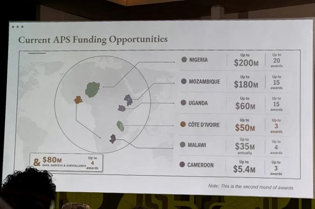
A recent U.S. government presentation at an international conference in Brazil drew attention after it displayed a distorted map of Africa. According to The Independent Uganda, the slide placed Nigeria in the Sahara as a landlocked state, moved Mozambique to the Horn of Africa and put Cote d’Ivoire on the wrong side of the continent. The U.S. State Department later acknowledged the error, saying the PowerPoint was hastily edited before the event.
The article says the mistake matters beyond the faulty graphic because it reflects broader gaps in how Africa is perceived in some Western policy and media settings. It notes that the Nigeria-Niger confusion has appeared before in public discourse and that AI and other digital tools can amplify existing assumptions rather than create them from scratch.
The piece also places the episode in a wider context of growing Western interest in Africa’s critical minerals, transport corridors and strategic role. It argues that viewing the continent mainly through resources misses the diversity of its 54 countries and about 1.4 billion people. As background, the article connects this to longstanding criticism of map projections such as Mercator, which African Union-backed campaigns say can distort the continent’s scale and reinforce outdated views.
Loading debate for this article…
Other publishers covering this story
No additional verified coverage is currently clustered with this report.
Related reporting
 Reports: US, Houthis make secret deal over Yemen warAl Jazeera
 UK and Canada discuss AI risks and defence ties in first bilateral meetingAl Jazeera
 Congress passes sweeping US sanctions bill targeting RussiaAl Jazeera
 US CENTCOM tells Al Jazeera Hormuz blockade ‘highly effective’Al Jazeera
 Trump says Canada becoming EU ‘associate member’ could be ‘hostile act’Al Jazeera
 NHL superstar Ovechkin ‘was asked’ to film Putin ad, team saysAl Jazeera